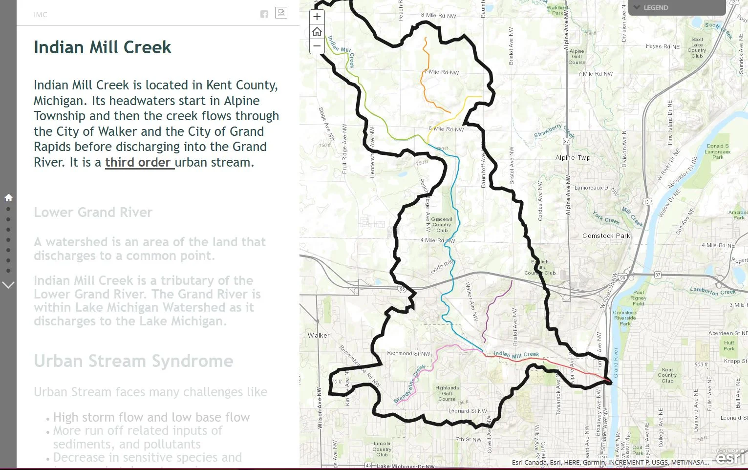
Grand Valley Metro Council
Home
About GVMC Budget & Finance Membership Employment Opportunities Staff Directory Contact
About MPO Committee Minutes & Agendas Metropolitan Transportation Plan (MTP) Transportation Improvement Program (TIP) Unified Planning Work Program (UPWP) Clean Air Action Geographic Information Systems (GIS) Open Data Portal Other Activities and Resources Get Involved
About REGIS Member Login Portal Public GIS Portal Map Gallery Help Desk REGIS Staff Support Center
About Environmental Programs Municipal Separate Storm Sewer System (MS4) Lower Grand River Organization of Watersheds (LGROW) Regional Prosperity Initiative Water Trails Climate Pollution Reduction Grant Staff
Home GVMC About GVMC Budget & Finance Membership Employment Opportunities Staff Directory Contact Transportation - MPO About MPO Committee Minutes & Agendas Metropolitan Transportation Plan (MTP) Transportation Improvement Program (TIP) Unified Planning Work Program (UPWP) Clean Air Action Geographic Information Systems (GIS) Open Data Portal Other Activities and Resources Get Involved REGIS About REGIS Member Login Portal Public GIS Portal Map Gallery Help Desk REGIS Staff Support Center Environmental Programs About Environmental Programs Municipal Separate Storm Sewer System (MS4) Lower Grand River Organization of Watersheds (LGROW) Regional Prosperity Initiative Water Trails Climate Pollution Reduction Grant Staff
Grand Valley Metro Council
Single Source Map Viewer

Single Source Map Viewer

The Single Source Map Viewer shows generalized codes for the region to provide a useful resource for GVMC programs/members, Regional Prosperity Efforts, Economic Development Partners, etc.

PASER Condition Map

PASER Condition Map

A map of the PASER ratings of federal aid roads in the GVMC MPO area.

Asset Management Vehicle Map Application

Asset Management Vehicle Map Application

A map of images, Pavement Surface and Evaluation Survey (PASER) ratings, and Internation Roughness Index (IRI) condition data collected by the GVMC Transportation Department for roads in the GVMC Metropolitan Planning Organization (MPO) area.

Plainfield Township PASER Condition Map

Plainfield Township PASER Condition Map

This map includes PASER ratings for federal aid roads AND local roads for Plainfield Township.

A Grand Restoration

A Grand Restoration

Story map of the Grand River Restoration project. Learn about the history of the Grand River and the benefits of restoring it.

Grand River Restoration Trail Map

Grand River Restoration Trail Map

Walk the Grand River Restoration Trail and experience these important and historical sites along the way.

Indian Mill Creek

Indian Mill Creek

Storymap of the Indian Mill Creek. Learn about the Indian Mill Creek, Lower Grand River Watershed, Urban Stream Syndrome, and more!

City of Walker Parks

City of Walker Parks

A map created for the City of Walker’s Parks and Recreation Department. A useful tool to get details about each park within the City of Walker.

1 2 3 4 5 6 7 8
Previous Next
Single Source Map Viewer
PASER Condition Map
Asset Management Vehicle Map Application
Plainfield Township PASER Condition Map
A Grand Restoration
Grand River Restoration Trail Map
Indian Mill Creek
City of Walker Parks
Grand Valley Metropolitan Council
678 Front Avenue Northwest,
Grand Rapids, MI, 49504,
United States
6167763876
Hours
Mon 8am to 5pm
Tue 8am to 5pm
Wed 8am to 5pm
Thu 8am to 5pm
Fri 8am to 5pm

Office Hours

Monday : 8am–5pm
Tuesday : 8am–5pm
Wednesday : 8am–5pm
Thursday : 8am–5pm
Friday : 8am–5pm

Location

678 Front Ave. N.W.,
Suite 200
Grand Rapids, MI 49504

Contact

General: (616) 776-3876
Transportation Planning: (616) 776-7610
REGIS: (616) 776-7744
Environmental Programs / LGROW: (616) 776-7605