

Lower Grand River Organization of Watersheds (LGROW)
The Lower Grand River Organization of Watersheds (LGROW) is the Department of Environmental Programs in the Grand Valley Metro Council. This puts LGROW in a unique position to blend non-governmental organizations with the local government members of GVMC. This collaboration empowers communities to protect and revitalize the Lower Grand River watershed. Visit the LGROW website for more information about this department.
1. Healthy Watersheds
WATERSHED MANAGEMENT, WATER QUALITY, & Total maximum daily load (TMDL)
LGROW developed the Lower Grand River Watershed Management Plan, which describes a framework for improving water quality in the watershed, specifically addressing non-point source pollution. Implementation strategies include addressing agricultural runoff, preserving and restoring regional green infrastructure, and installing local, site-specific low impact development practices. Involving partners who are responsible and able to acquire and manage land for habitat and water resource protection is vital for the future health of a watershed. The Watershed Management Plan is available here.
Total Maximum Daily Load, or TMDL, is a document that defines the process used to establish the pollutant load a water body can contain while simultanously meeting water quality standards for its designated use(s). Common TMDL pollutants are E.coli, dissolved oxygen (DO), nutrients, and sediment. As of 2016 the State of Michigan has 56 EPA approved TMDLs for E.coli alone. Common causes of elevated levels of E.coli are unfiltered stormwater runoff into storm drains from agricultural fields and pastures, as well as human sources from septic failures.
NATURAL CONNECTIONS
Green Infrastructure
Freshly planted curb cut bioswale collecting, filtering, and storing stormwater runoff as well as preventing street flooding. This bioswale was a part of the Great Lakes Restoration Initiative.
Green infrastructure is the practice of infiltrating stormwater by use of natural systems in order to reestablish a healthy water flow. These systems allow for the infiltration of stormwater before it is released into conventional storm sewer systems, protecting our lakes, rivers, and streams from harmful pollutants. Green infrastructure practices promote healthy community features such as public parks, forests, rivers, wetlands, and lakes. Using these natural systems to treat stormwater results in cleaner water, improved air quality, healthy wildlife habitats, and safer recreation sites. Urban areas are required to meet state and federal regulations to clean up rivers and reduce stormwater runoff. With green infrastructure, these communities can create comprehensive plans, determine new development areas and redevelop other areas in need and will improve local communities and attract jobs.
The Lower Grand River Organization of Watersheds (LGROW) strives to provide opportunities for local partners to actively participate in solving watershed problems through innovative education and tools for action. One of these tools created through a partnership is the “Natural Connections Map”, which illustrates the regional green infrastructure framework in the Lower Grand River Watershed. This area of over 3,000 acres consists primarily of upland forests, typically associated with larger hub areas; and lowland forests and wetlands, typically associated with the riparian lands along rivers, creeks, lakes, and ponds. The hubs and corridors identified on the map have the greatest potential to provide an interconnected network of land and water that supports native plant and animal species, maintain ecological processes and services, sustain air and water resources, and contribute to the health, well-being and quality of life of people and communities throughout the region. LGROW and its partners are currently using this framework to engage local governments in advancing the critical policy issue of green infrastructure and low impact development.
The future of Great Lakes Restoration will not be in cleaning up Areas of Concern or legacy pollutants. These areas have the current focus of federal, state and local agencies, and the funds are being allocated to complete the jobs and make these areas safe for residents and visitors to enjoy in our lifetime. For the future, however, our focus will have to be on keeping the green places green, and making improvements in other areas as we can. A regional green infrastructure plan allows communities to see the vital connections that our resources have to each other, and realize how small changes in one area can have an impact far greater than just its footprint. Partners ranging from federal agencies, such as the Natural Resource Conservation Service, to local groups, such as Plaster Creek Stewards, are working together to create the network of habitats and practices that are needed to protect the natural resources of the Lower Grand River Watershed.
Rainscaping
Rainscaping demonstration site at West Catholic High School, in the Indian Mill Creek watershed. Learn more at lgrow.org/rainscaping
The LGROW Rainscaping Program: Treating Stormwater Naturally using a method of watershed management that promotes green infrastructure awareness and implementation among homeowners, landscapers, and contractors. The program highlights both the benefits of green infrastructure and the skills required for installation. Rainscaping practices include rain barrels to collect stormwater from rooftop runoff, rain gardens that collect, filter and store runoff, curb cuts that divert runoff from streets to rain gardens, and more.
LGROW offers free property assessments and information on how to get started with your own Rainscaping project. With funding from the National Wildlife Federation, Sacred Grounds program LGROW continues the Grand River Rainscaping Program. LGROW has many partners who offer native plants, rain garden design, rain barrel workshops, and more.
SUSTAINABLE AGRICULTURE
The effects of our everyday activities on natural ecosystems are visible everywhere: native habitats are degraded, wildlife movement is obstructed, surface and groundwater quality is impaired, flooding is more frequent and severe, and our agricultural land is disappearing. West Michigan’s fertile soil, diverse microclimates and strong network of farms and farmers are vital to Michigan’s economy. Kent County alone contributes $1.5 billion to our state’s agriculture economy every year and that economic contribution continues to grow. Farmland plays a crucial role in insuring a strong economy in West Michigan. Kent County has issued a draft report that provides ways to promote a stronger agribusiness economy and recommendations for a comprehensive plan to preserve critical farmland. West Michigan understands the importance of education regarding the positive economic impact of agribusiness and the need for local business and government leaders to work together to preserve farmland. In 2010, the Kent County Board of Commissioners accepted a subcommittee report that contained ways to sustain the funding of a farmland preservation program. The report recognized that community planning and zoning are key issues that local government leaders and citizens deal with frequently. GVMC understood that a comprehensive map of West Michigan detailing the zoning and planning within each municipality would be of great assistance to all concerned. With that goal in mind, GVMC has recently committed to develop a comprehensive, single-source database for Region 4, looking at zoning (including farmland), recreation, transportation, watersheds, parks, infrastructure, and other attributes to be able to consider regional implications when making land use decisions. GVMC will work with communities to review annually and update the database as new information becomes available.
GVMC is also working with the Natural Resources Conservation Service on the recently awarded Regional Conservation Partnership Program grant to implement agricultural conservation practices in the Rogue River and Indian Mill Creek Watersheds. More information about that project can be found here. This work is guided by LGROW’s Sustainability Committee members and its current Chair, Rachell Nagorsen, City of Walker’s Engineering Programs Coordinator.
2. Engaged Community
ENVIRONMENTAL EDUCATION
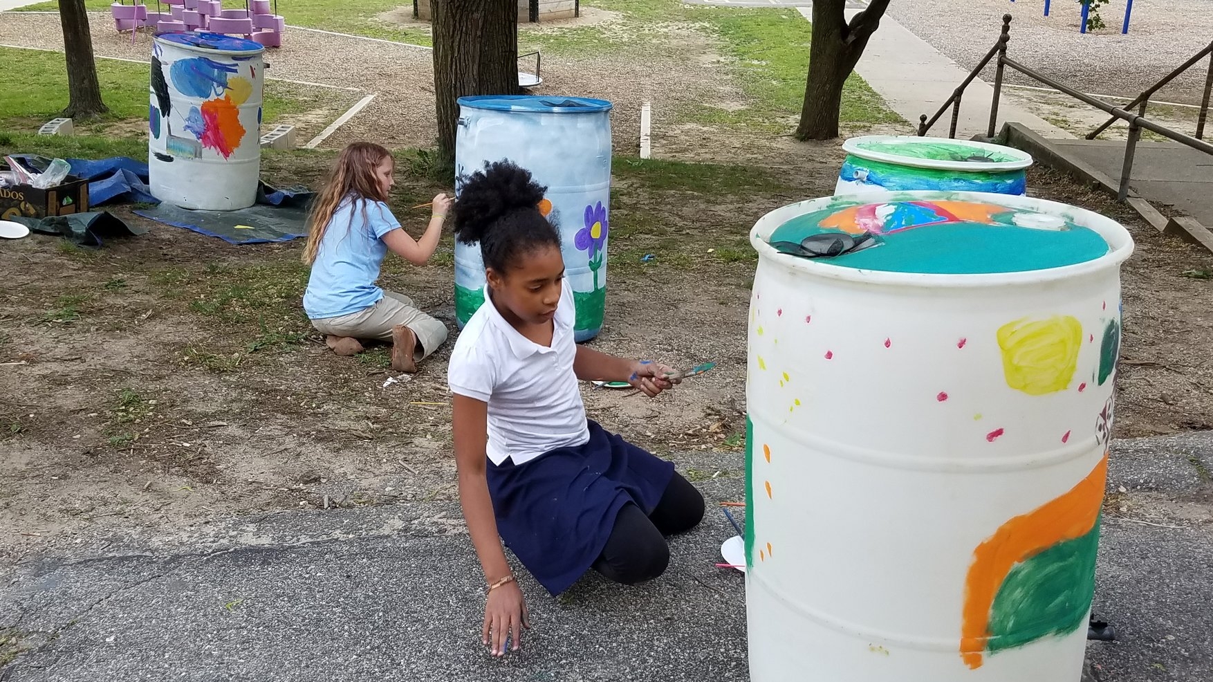
North Park Elementary students painting rain barrels at the GLRI Rain Barrel Workshop May 2017
GVMC and LGROW are involved in educating students throughout the Lower Grand River Watershed about stormwater, water quality, and general watershed stewardship. Through a Great Lakes Restoration Initiative (GLRI) grant, LGROW has been working with Rockford Public Schools, North Park Elementary, Parkside Elementary, and Calvin Christian High School in stormwater and watershed education and in installing and maintaining green infrastructure practices. LGROW also provides education through partnerships with organizations such as Groundswell and Plainsong Farm in Rockford, and by working directly with school districts covered under the MS4 stormwater program.
With support from the Great Lakes Stewardship Initiative and Groundswell, LGROW is also working with Kent Innovation High School and other public and private schools to involve students in project-based learning surrounding the Grand River Revitalization and Rapids Restoration spearheaded by Grand Rapids Whitewater.
In addition to direct school partnerships, LGROW provides education at local events such as the River City Water Festival held by the West Michigan Environmental Action Council (WMEAC) and the Grand Rapids Public Museum.

LGROW Staff teaching students about Non-point Source (NPS) pollution with the Pollution Solution Catch Basins. To learn more about stormwater pollution and how to prevent it visit www.lgrow.org/stormwater
3. Robust Organization
LGROW’s members and partners have formed four committees to address the issues and concerns of the Watershed, a technical committee, public engagement committee, sustainability committee, and a fund development and membership committee. These committees bring together members of the community and local municipalities to work together on watershed issues. To learn more about the LGROW committees, their goals, meeting dates, and to see agendas and minutes click here.
You can learn more about LGROW’s Board of Directors here.