

Airport Access Study
GVMC teamed up with the Gerald R. Ford International Airport, Michigan Department of Transportation, Kent County Road Commission, City of Kentwood, Cascade Township, AECOM, and other partners to investigate ways to improve access to the airport as well as the surrounding local road and freeway systems. Rapid growth and development at the airport, and in this part of the region in general, made now an important time to consider how to best provide access in the airport area into the future. The study examined current transportation needs and changing travel patterns including airport passenger and cargo traffic, road connections and access, traffic operations and safety, bike and pedestrian circulation, transit service, railroad connections, airport security, and terminal access redundancy. The study used an iterative process and extensive feedback from the public to evaluate different airport access alternatives, leading to a set of preferred projects and an accompanying implementation and action plan.
The study has been finalized and the report is available at the link below.
Airport Access Study Final Report
Study Process Overview
Existing Conditions Review
During the initial phase of the study, the project team did a comprehensive review of existing transportation, economic and land use conditions, as well as the previous regional and local planning efforts impacting the area. Detailed existing conditions information from the Study can be found in the Existing Conditions Technical Memo provided below.
Existing Conditions Technical Memorandum
Based on the existing conditions analysis and the first round of public engagement, project partners developed Purpose and Needs statements for the study.
Study Purpose
Expand multi-modal access options for the Gerald R. Ford International Airport and improve the connectivity of the surrounding local road and freeway network, in order to facilitate future airport expansion and accommodate regional growth and development (increasing population and jobs) in southeastern Kent County.
Study Needs
The study aims to improve or support the following issues:
Limited access points to the airport’s core
Indirect circulation around the airport and from major expressways
Provide for surrounding growth and development
Support for airport expansion plans
Expansion of convenient access options
Alternatives Development and Evaluation
The Study utilized a two-step evaluation process which consisted of an initial evaluation and a second round of detailed evaluation. A graphic illustrating this process is below and full summaries of the evaluation processes and their results are provided in the technical memos linked below the graphic.
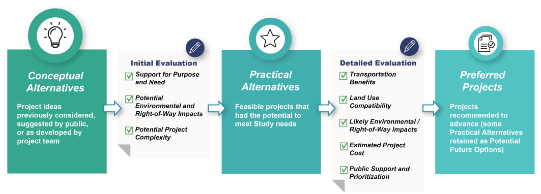
Initial Alternatives Evaluation Technical Memorandum
Practical Alternatives Evaluation Technical Memorandum
Public Engagement Overview
Three rounds of public engagement were conducted as part of this study:
Phase 1: Identify
Through a story map and survey, stakeholders and the public were presented key findings from the existing conditions analysis, the draft Purpose and Need, and conceptual alternatives and asked to rank and rate needs, identify location-based issues on a map, and provide feedback on conceptual alternatives. Thanks to a partnership with the airport, over 7,000 people took the survey including over 3,000 from the region. A summary of the regional results are below.
Phase 1 Survey Summary - Regional Responses
Phase 2: Examine
Through a story map and survey, stakeholders and the public were presented the practical alternatives and their pros and cons, and asked to provide feedback on those alternatives. Again, thanks to the partnership with the airport, over 6,700 people took the survey, including over 2,000 from the region. A summary of the regional results are below. Airport employee responses were also analyzed separately and that summary is also below.
Phase 2 Survey Summary - Regional Responses
Phase 2 Survey Summary - Airport Employee Responses
Phase 3: Advise
In the third phase of engagement, stakeholders and the public were presented the results of the evaluation of practical alternatives and asked to provide feedback on the list of “preferred projects.” This phase included an online story map and survey, a virtual public meeting, and two in-person open houses. A summary of the regional survey results is provided below.
Phase 3 Survey Summary - Regional Responses
Technical Advisory Committee
The Airport Access Study Technical Advisory Committee (TAC) was established at the study kickoff to advise on key study decisions and on the best ways to engage the public and other key stakeholders. Representatives from the following agencies/organizations made up this TAC:
MDOT Grand Region
Gerald R. Ford International Airport
Kent County Road Commission
Cascade Charter Township
City of Kentwood
The Rapid
Kent County
The Right Place
GR Chamber of Commerce
Experience GR
The TAC met four times during the course of the study. Meeting slides are provided below.
Technical Advisory Committee Meeting #1 Slides
Technical Advisory Committee Meeting #2 Slides
Technical Advisory Committee Meeting #3 Slides
Technical Advisory Committee Meeting #4 Slides
Next Steps
The development of this Airport Access Study was the initial step toward achieving a set of projects and services that will enhance the resilience and reliability of connections to the Airport. In the future the infrastructure owners (including the Airport, MDOT, Kent County, The Rapid, and the local cities/townships) will need to conduct more detailed design studies, environmental reviews, and potentially funding applications prior to construction occurring.
GVMC will continue to engage with project stakeholders and provide technical assistance, as appropriate, to assist project sponsors toward implementation of the preferred projects.
Banner photo courtesy of Gerald R. Ford International Airport